
Machine Learning training
Machine Learning Training
VRSG’s extensive, highly-accurate 3D models, geospecific terrain datasets, and sensor simulation capabilities support AI/Machine Learning training for Large Language Model (LLM) active development programs.
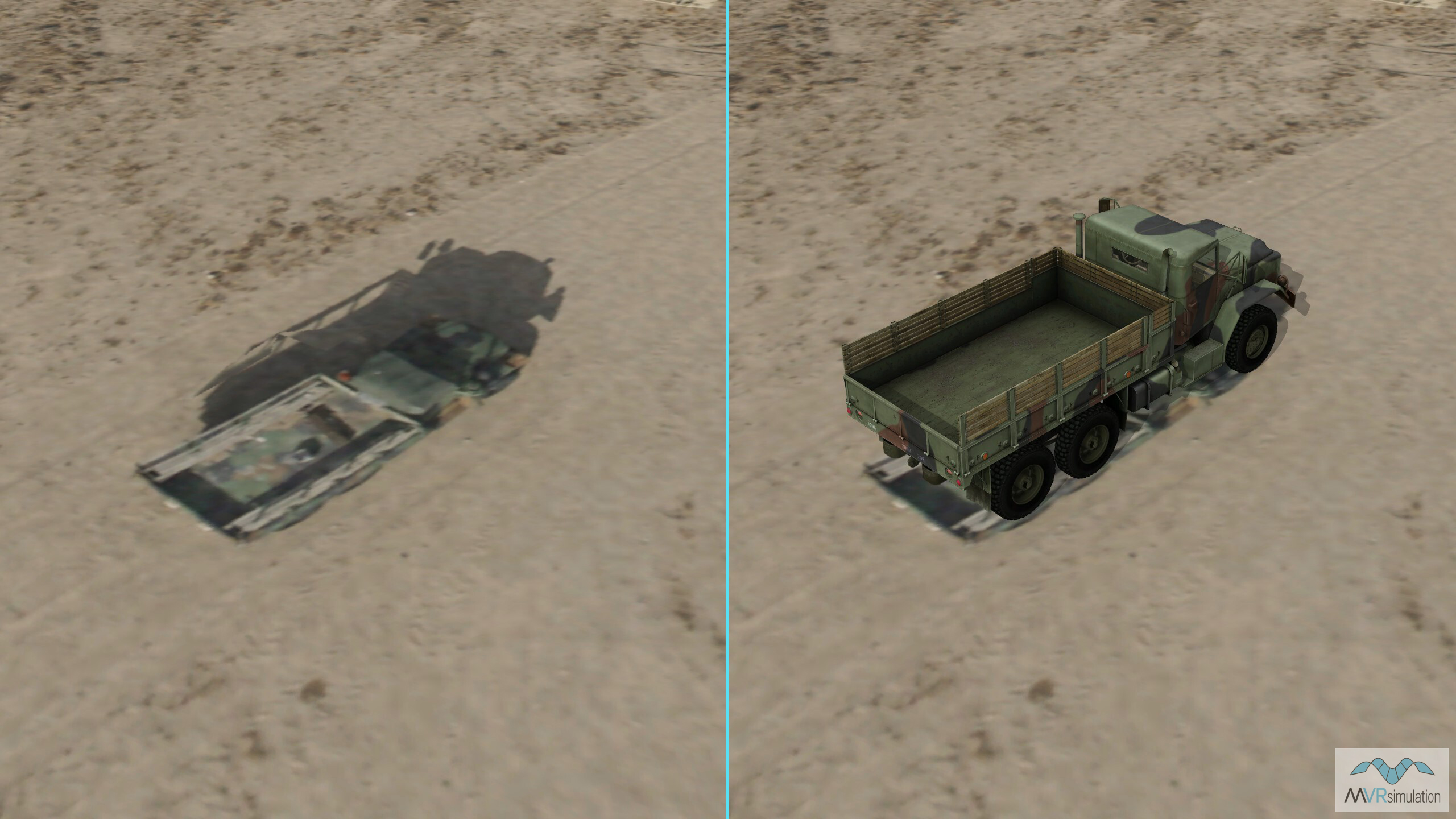
Real vehicle captured at Fallon Training Range by a UAV sensor (left), and a VRSG 3D model entity of the same vehicle type in VRSG's virtual Fallon terrain (right). Notice original image shadow has the sun low and behind the vehicle, and in the VRSG scene the sun is higher and more lateral. A key benefit of using VRSG + 3D Model + Terrain is the ability to set various sun angles to train LLM to better discern a given vehicle from shadows in aerial sensor footage.
VRSG and AI Training
AI programs require vast quantities of data to train on, and access to the kind of large-scale datasets needed to do this for defence and intelligence applications is limited in the real world.
VRSG’s ability to accurately depict highly realistic operational environments populated with highly accurate 3D models provides a foundation for producing these large-scale, high-fidelity and multi-modal datasets needed to train AI/Machine Learning tools in missions such as target identification, recognition and acquisition for ISR applications being developed for military users. The whole-world VRSG terrain database includes high-resolution insets of AOIs including dense urban areas and military training sites, enabling training scenarios to be built in extensive settings, in limitless weather, light and environmental conditions; and the VRSG 3D model library is extensive and continually updated with replicas of real-world military platforms being developed and deployed by military forces worldwide.
Beyond current development programs, VRSG also provides a testbed environment in support of longer term Machine Learning innovation programs focused on prototype technologies such as AI and human-machine teaming.
Under VRSG’s AI/Machine Learning set-fee licensing mechanism, users can export VRSG’s 3D content, including visually accurate 3D military platforms and high-resolution geospecific terrain, in nearly limitless depictions for direct input into LLM for end user applications.
VRSG can visualize military platforms in 3D terrain from any given angle, enabling LLMs to accurately and reliably identify the platform in real-world environments.
Applications
- Target recognition and identification: Use scripted multi-angle datasets generated from VRSG’s 10,400+ 3D models to train and validate AI classifiers to train AI agents to recognize vehicles, aircraft, and weapons using VRSG’s highly-accurate 3D models in different terrain, light and weather conditions.
- ISR video streaming exploitation: VRSG’s ability to simulate and record H264 full motion video data link feed from simulated overhead airborne assets complete with MISB-complaint KLV metadata, can be used to train AI agents to analyze RPAS, sUAS and manned aircraft payload sensor streams for ISR, persistent surveillance and automated change detection applications.
- Autonomous flight navigation: VRSG’s ability to accurately render the flight dynamics of high-fidelity flight models within high-resolution, geospecific terrain can provide datasets for training AI-piloted sUAS and drone swarms to safely navigate in realistic terrain, including forested, urban and other cluttered environments.
- Ground vehicle navigation support: Train AI agents to navigate obstacles, avoid collisions with other manned and unmanned ground vehicles, and travel safely in convoy using VRSG’s high-resolution terrain (as high as 2cm per pixel), including different ground textures such as beaches, runways, urban areas with damage states, and conflict areas where trenches, underground tunnels or other terrain hazards are present.
- Human behavior modeling: Provide a safe synthetic testbed environment to test and validate AI decision making for AI/Human teaming and conflict, including integration with semi-automated forces (SAF) software; such as distinguishing civilians from threats in urban terrain.
- Operator decision support: Provide a safe synthetic testbed environment for training AI agents to provide combat decision support to JTACs and CAS operators.
- Electronic warfare (EW) tactics: VRSG’s ability to simulate adversary radars and communication nodes provides a training dataset for testing AI agents in spectrum management, adaptive jamming, and counter-jamming strategies. It can also simulate GPS jamming and GPS-denied environments, allowing AI agents to train battle tactics when communications, navigation and visual/voice communication methods are compromised.
A VRSG scene showing JTACs operating FPV UAVs to attack targets.
A JTAC scene showing targets in VRSG's Camp Pendleton terrain.
Continuously updated model library
VRSG’s model library includes more than 10,400 3D models for use in scripted multi-angle datasets, including military platforms such as vehicles, aircraft, maritime vessels, radar, weapon systems and munitions, as well as buildings, characters and cultural entities. The library is continually updated with the latest military and civilian platforms deployed in conflicts around the globe.
- Each model entity includes highly-detailed geometry
- Vehicle and munition models include articulated parts, damage states, and advanced animations such as moving wheels or tank tracks that turn at a rate coupled to vehicle velocity
- Models support time real-time, physics-based thermal sensor viewing within VRSG
- Models are available in multiple, accurate paint schemes
- VRSG’s configurable environmental effects settings replicate the varied appearance of assets in different light/dark/shadow and weather conditions
- VRSG users on active software maintenance can access all new and updated models as they are added to the library, at no additional costs
- Users can also request new models for inclusion in the library.
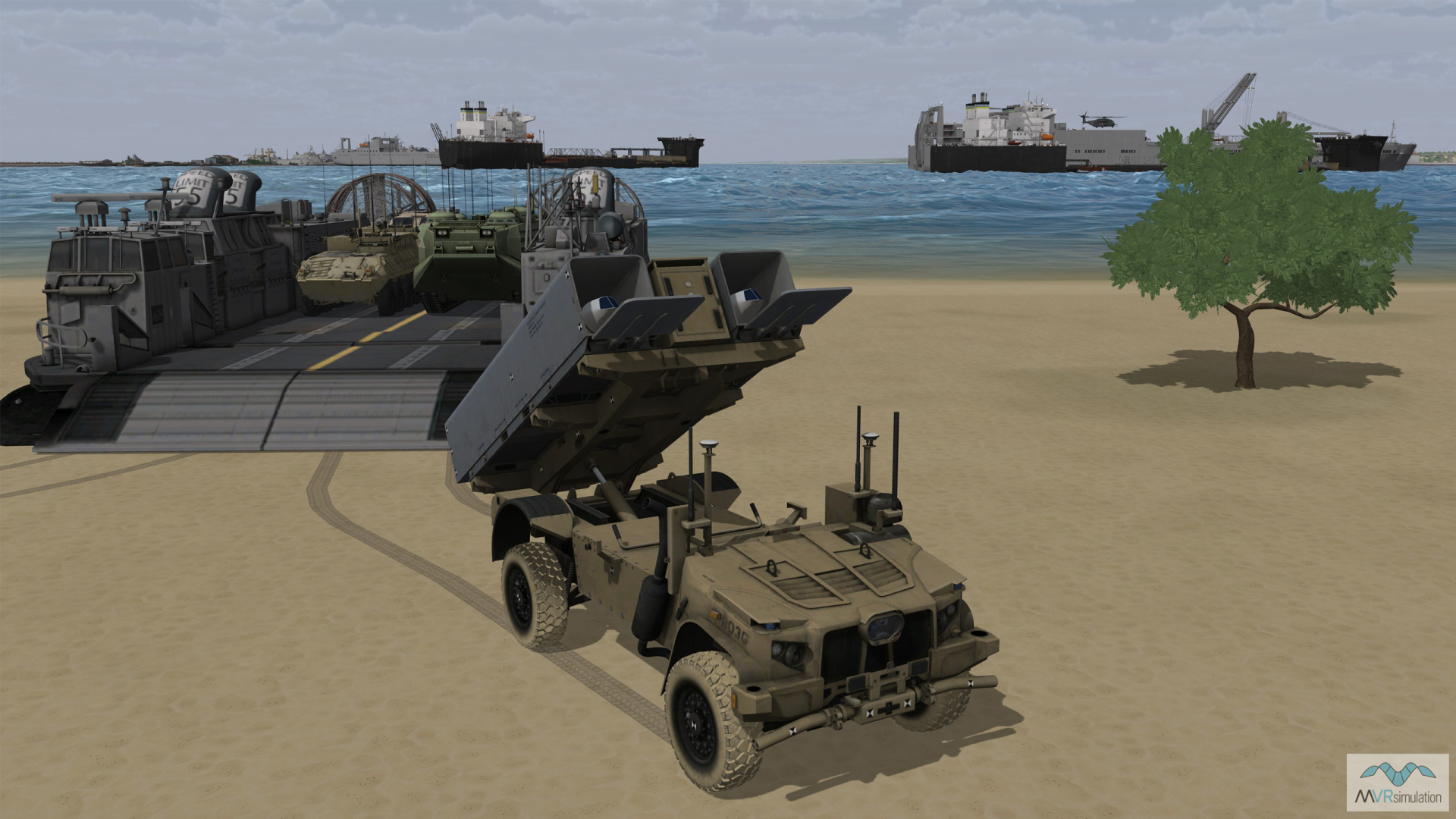
Real-time scene showing a JLTV Rogue disembarking from an LCAC in VRSG's high-res Kismayo terrain dataset.
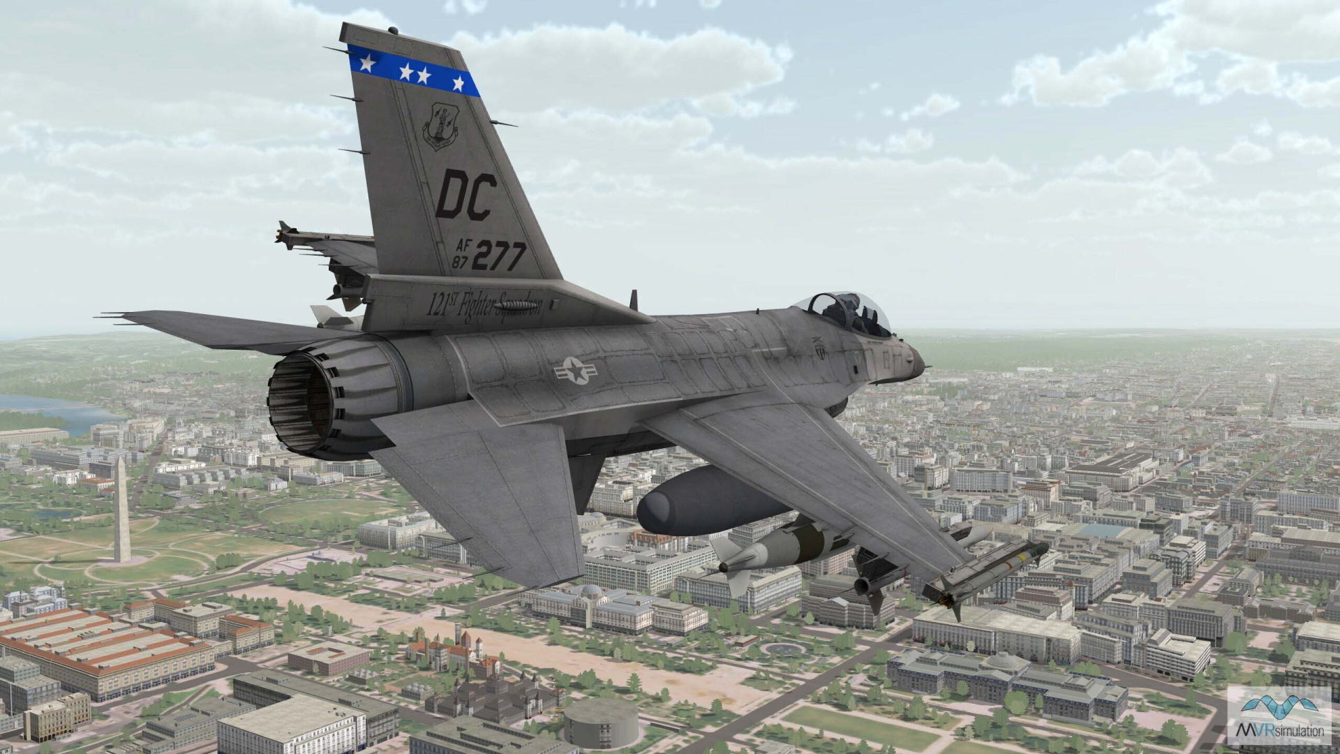
Real time 3D model of an F-16 in flight over VRSG's Washington DC terrain, built using 1-meter NAIP imagery.
VRSG terrain datasets
VRSG’s whole world terrain database provides an extensive range of real-world, geospecific terrain datasets, including military training ranges and airfields, to support AI training agents. It also provides a range of AOIs designed for specific training requirements, such as dense urban areas (geospecific and representative), coastal areas, and dense forested areas.
Users can create limitless scenarios using VRSG's Scenario Editor. This allows users to quickly create, populate and edit 3D scenarios for play back in VRSG. Via Scenario Editor's game-level editor type interface, users add content from VRSG's model content libraries directly to 3D terrain to create dense, 3D scenes with rich culture, realistic visual characteristics, and scripted movements of vehicles and characters in order to run tactical training scenarios.
Users wanting to create their own classified training areas from their own geospatial data can be built using the Terrain Tools for ArcGIS® Pro extension (Terrain Tools license required) for rendering in VRSG.
All terrain datasets can be adjusted to reflect changing lighting, weather and environmental conditions, providing the variation required for large-scale, high-volume, and repetitive AI agent training.
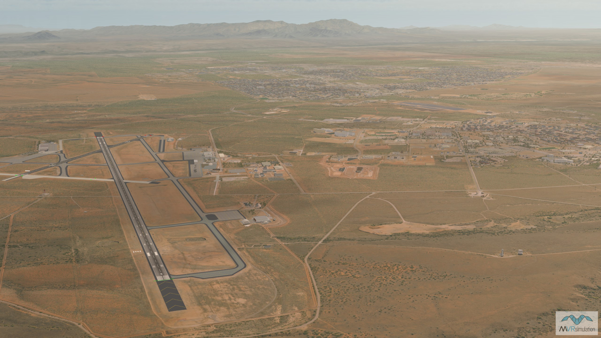
VRSG's 3D terrain model of Libby Army Airfield (KFHU) and the surrounding area of Sierra Vista, Arizona.
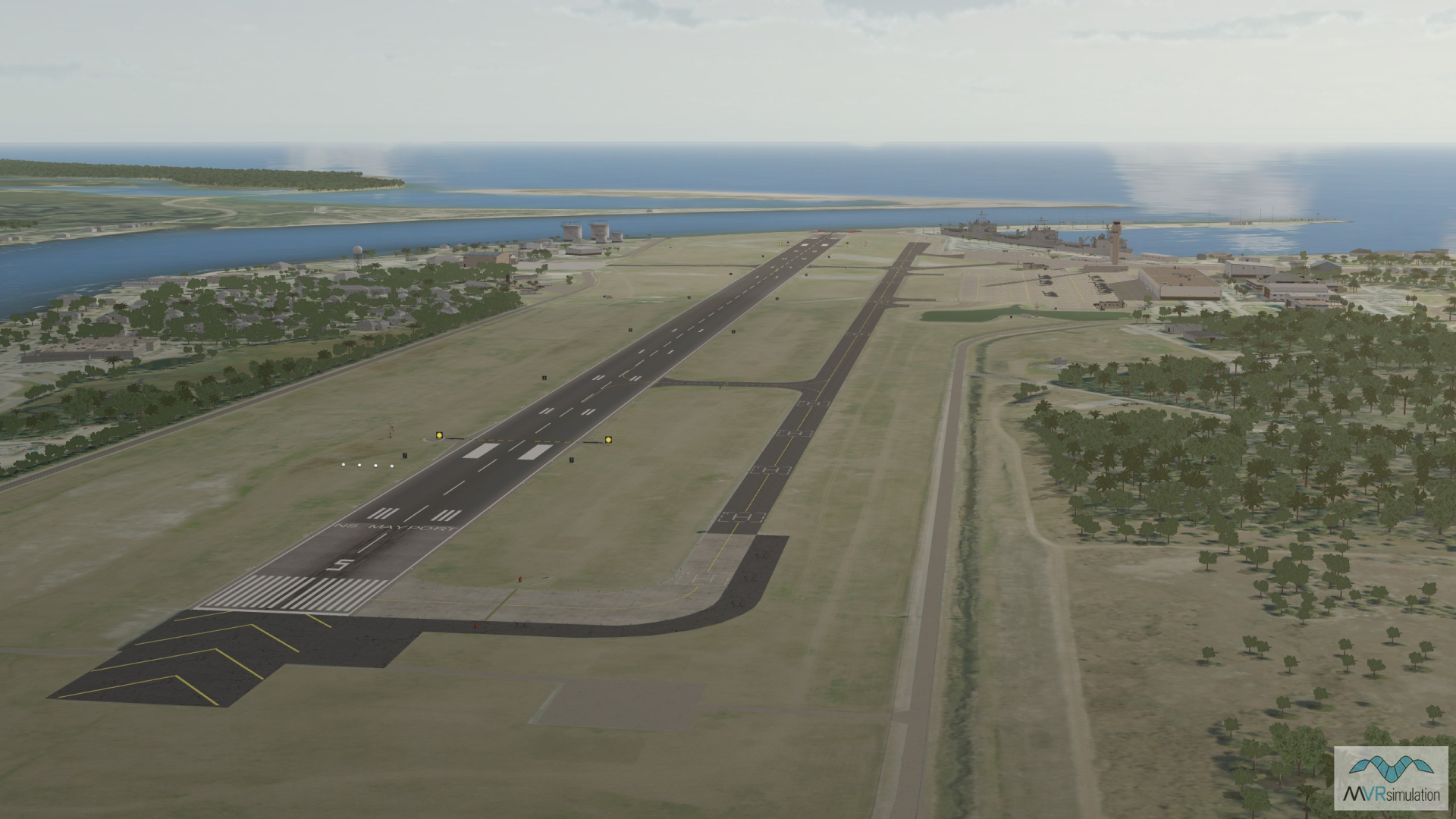
VRSG's Mayport Naval Station dataset, compiled using 10-meter resolution elevation data from the NED USGS.
For pricing, please see the price list and request for quote form.