
VRSG Integration with ATAK
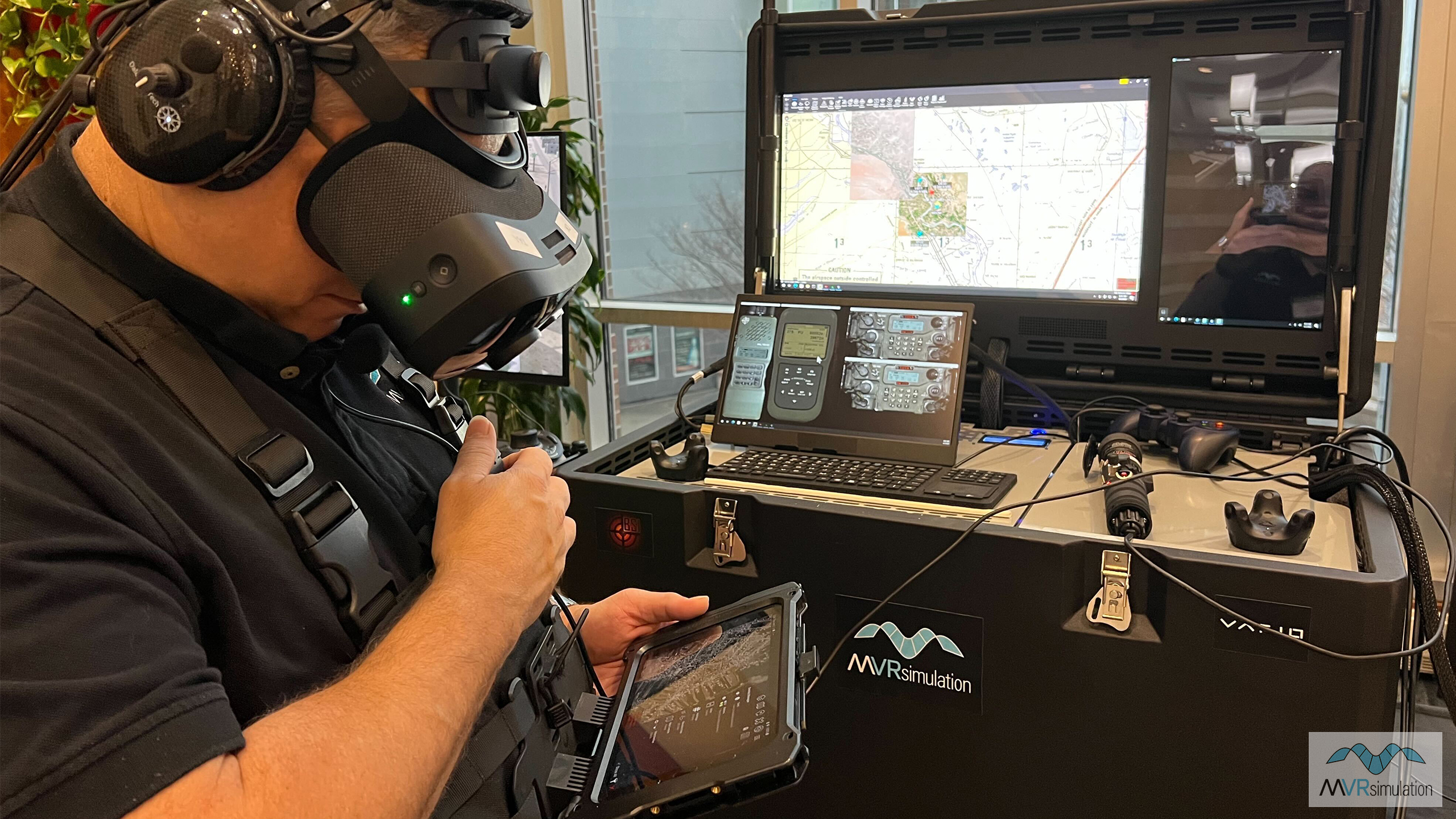
A JTAC trainee at the Observer station uses an Android tablet running ATAK in the chest harness as part of MVRsimulation's DJFT.
The DJFT uses Battlespace Simulations’ MACE as its semi-automated forces software to run simulated training scenarios. MACE can integrate with a number of Digitally-Aided Close Air Support (DACAS)-capable awareness toolkits used by JTACs in live missions, including Sierra Nevada Corporation's ATRAX/TRAX on Android Team Awareness Kit (ATAK) and WinTAK; Battlefield Airmen DataLink (BADL) in the Special Warfare Assault Kit (SWAK); Stauder Corporation’s Joint Effects and Coordination Link (JECL); and Accenture's FACNAV.
MACE can integrate with these toolkits via Link 16; using a built in JREAP-C server or client; or via VMF systems using BSI's VMF Gateway plugin for MACE.
To enable JTACs to train for DACAS, the DJFT ships with SWAK (ATAK+BADL) capability. This allows the trainee to manage the geospatial awareness information required for the mission exactly as they would in real life missions.
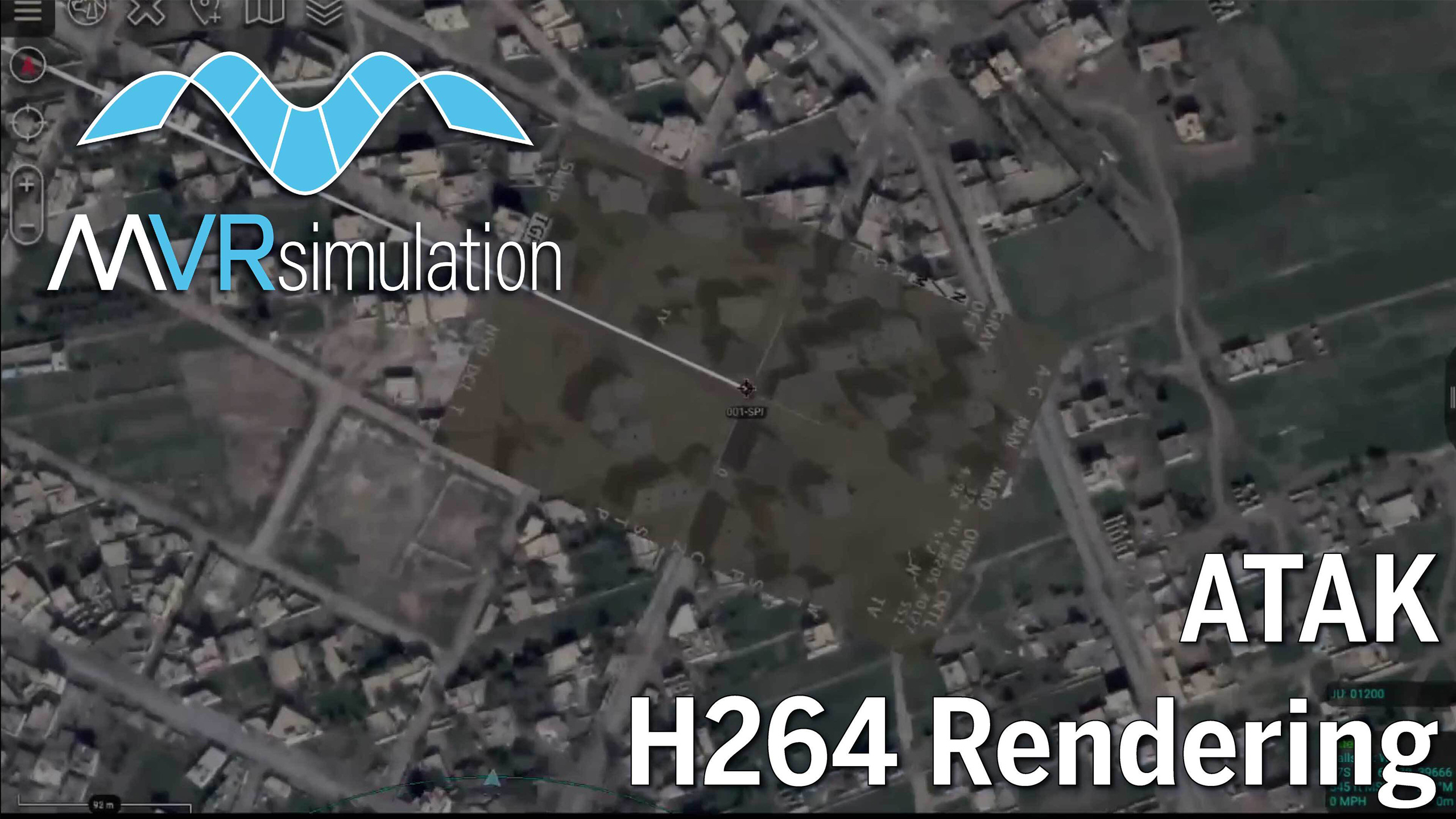
MVRsimulation’s VRSG can simulate H264 video data link feed from an overhead airborne asset, complete with MISB-complaint KLV metadata, for display on video datalink receivers such as remotely operated video-enhanced receiver (ROVER) devices, or ATAK/WinTAK. When coupled with MVRsimulation's 3D visualization technology, VRSG generates the simulated 3D scene and the range and coordinates of a designated target on the device's monitor.
In ATAK, the VRSG video stream can be overlaid on the tactical map the JTAC is using to manage geospatial information to ensure all parties in a DACAS mission are correlated on the correct target. Using the KLV metadata embedded in the VRSG video stream, ATAK can display the aircraft's position marker as well as its Sensor Point of Interest.
In this video, VRSG-simulated H264 video data link feed from a (simulated) Sniper pod is overlaid upon the imagery in ATAK. ATAK uses the KLV metadata embedded within the data stream to render the video georeferenced as an overlay upon a 2D map. Note how the roads and buildings line up between the static ATAK imagery and the real time 3D VRSG virtual terrain of Hajin, Syria.
The advantage of using VRSG and MACE in the DJFT is it empowers JTACs to train with the same DACAS toolkit they will use in real world combat scenarios. They build the procedural knowledge and muscle memory necessary to do their jobs efficiently, greatly reducing time to kill while maximizing blue force survivability.
ATAK running with a VRSG simulated UAS video feed, facilitated by KLV metadata.
Government off-the-shelf SWAK (ATAK + BADL) running on the MVRsimulation DJFT.
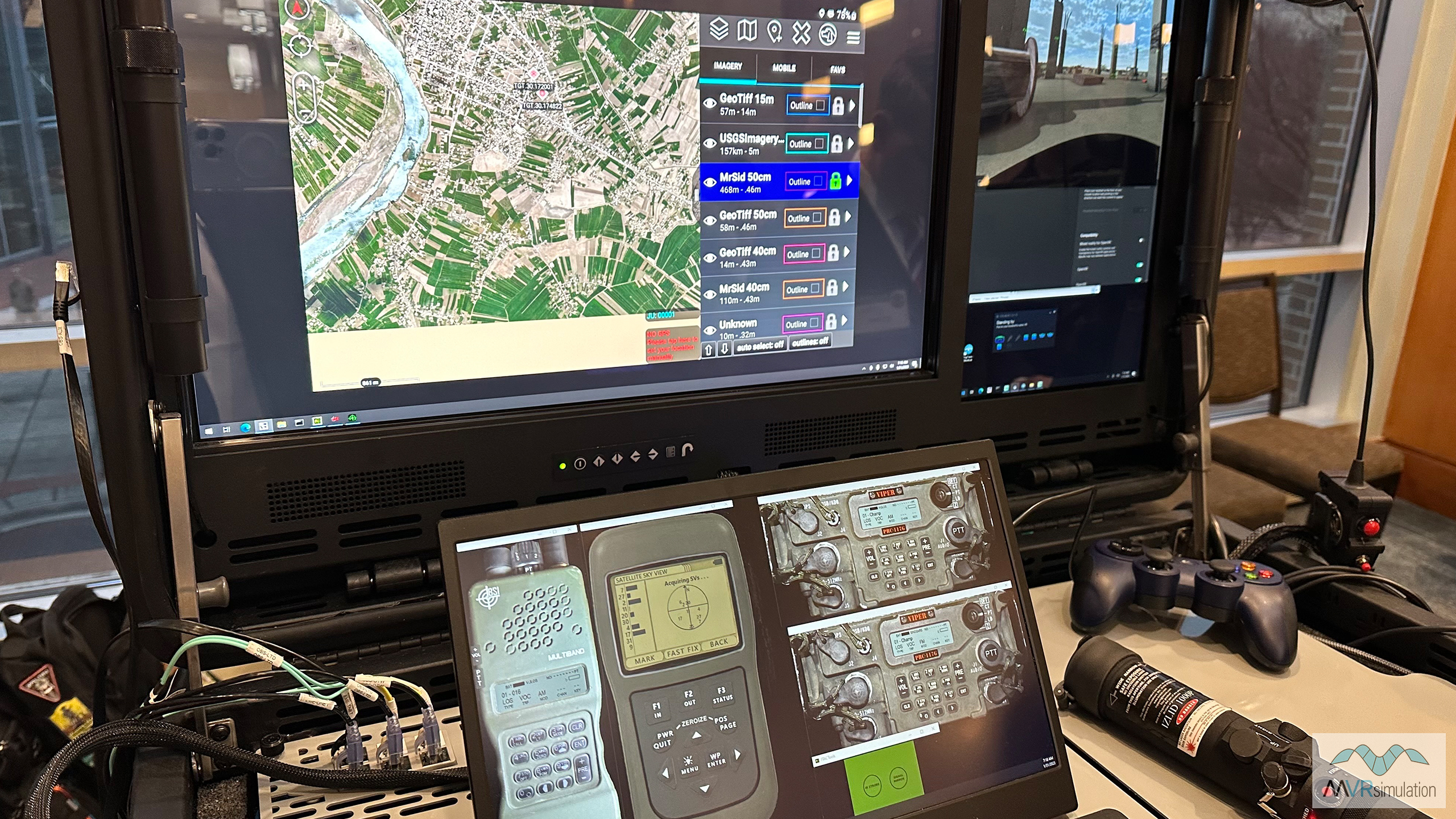
ATAK and KLV metadata
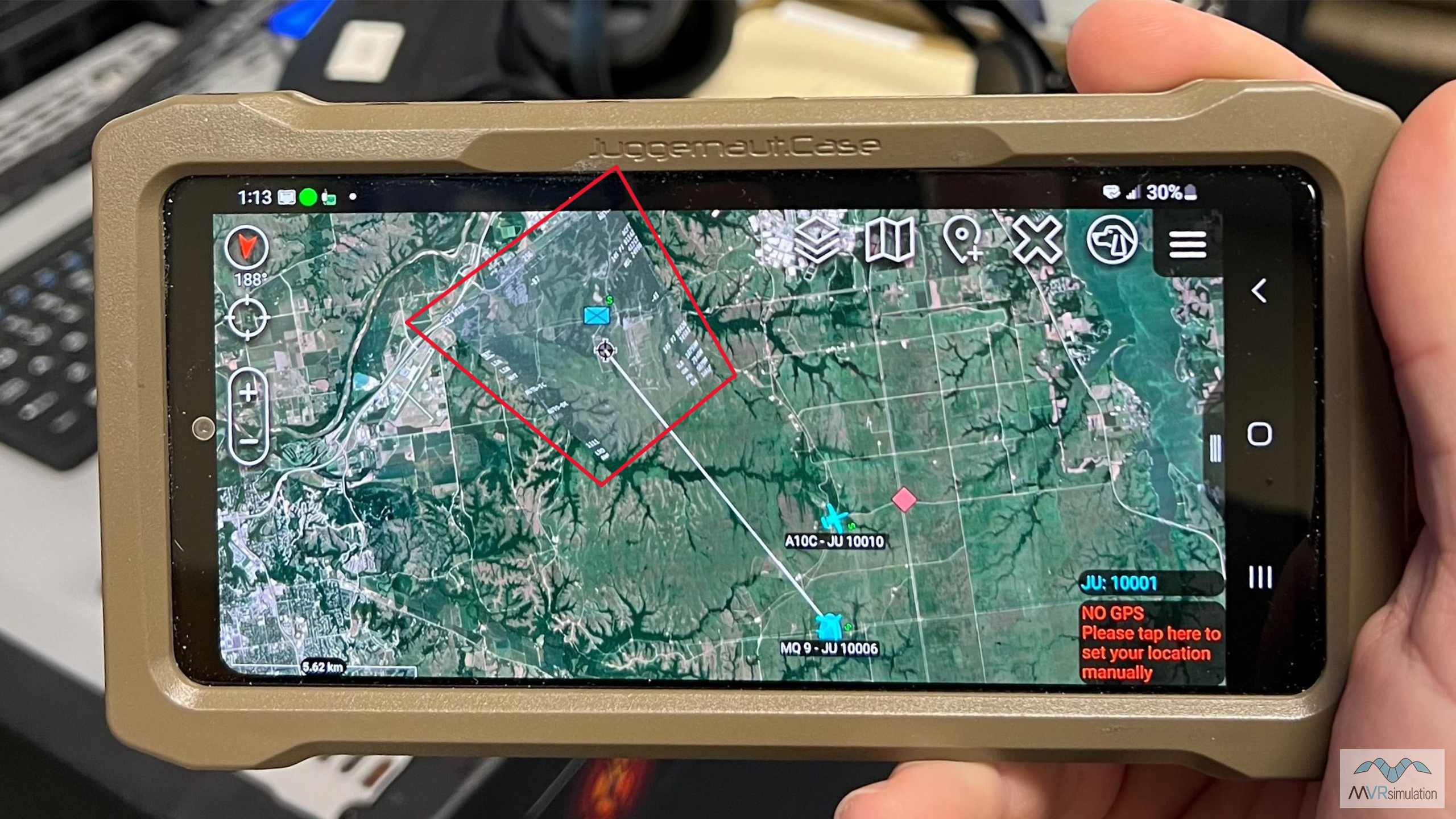
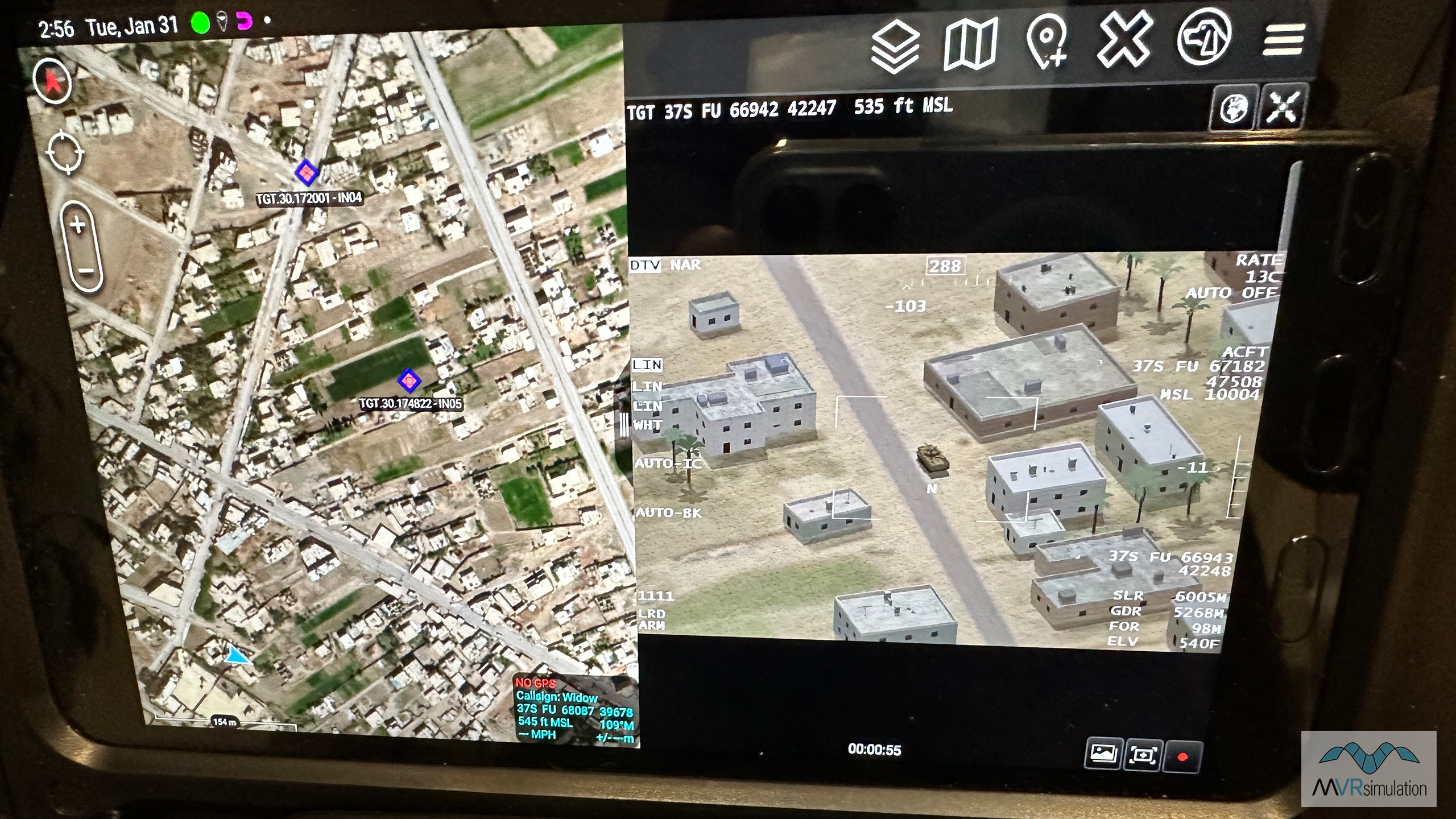
A JTAC trainee's end user device showing VRSG overlay of a sensor video feed (shown here inside the red box) on the ATAK map (in this instance, Google satellite imagery).
ATAK integration into the DJFT simulator is not limited to just the situational awareness features. MVRsimulation's VRSG image generator is able to generate streaming H264 video with STANAG compliant KLV metadata. On the JTAC trainee's SWAK tablet ATAK is able to overlay a sensor video feed (shown here inside the red box) onto the map (in this instance, Google satellite imagery), allowing the user to correlate the sensor video footprint with other situational awareness elements. VRSG provides this simulated UAS sensor video feed (replicating that provided to the JTAC by an overhead MQ-9 RPAS in the real-life mission), allowing for a more comprehensive JTAC training environment.
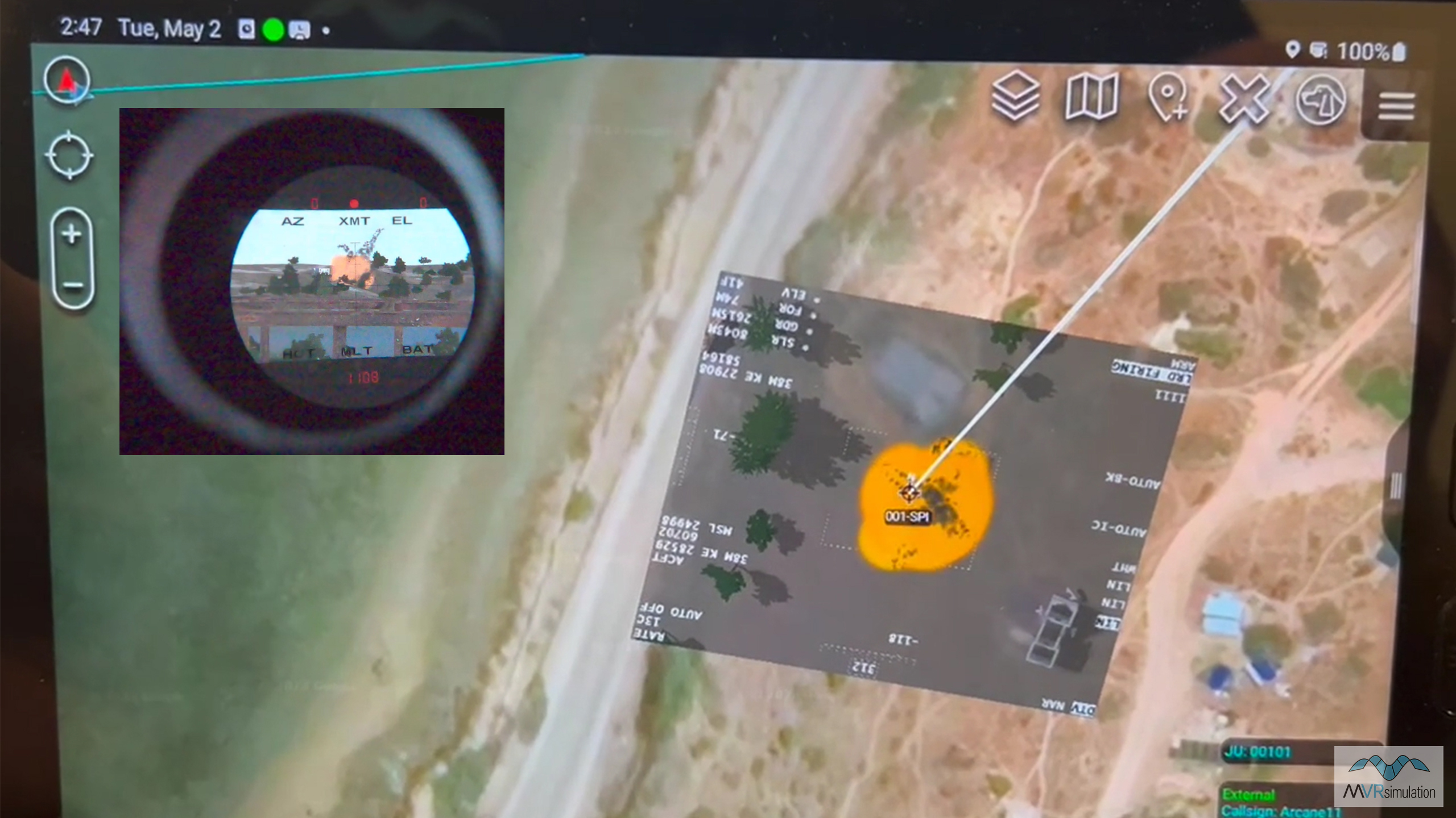
A target is hit, as viewed on the VRSG sensor feed on the SWAK (a Samsung Galaxy Active Tab 3), and (inset) through the JTAC’s SOFLAM laser target designator.
VRSG's recording feature simulates a plug-and-play video feed for applications such as the SWAK ie., ATAK. VRSG records a high quality and high-performance MPEG encoded video stream in real time with support for KLV metadata encoding. During a #CAS training mission, the DJFT Role Player station can be configured as (for example) an MQ-9 Predator RPAS, sending VRSG sensor feed overwatch visuals to the JTAC Observer. The VRSG sensor feed includes the required KLV metadata embedded in the video stream based on the MISB ST 0601 standard commonly used for air systems. The KLV metadata provides the geospatial information needed to geolocate the sensor feed into ATAK on the JTAC trainee's SWAK tablet. VRSG delivers the video feed directly to the SWAK kit allowing the student to train in the same environment they would be using in the field.
This photo shows the same moment a target is hit viewed on the VRSG sensor feed on the SWAK (a Samsung Galaxy Active Tab 3), and (inset) through the JTAC’s SOFLAM laser target designator.